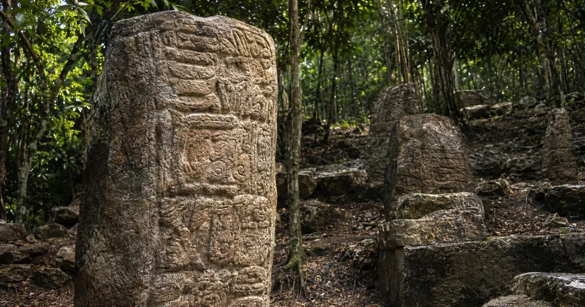

A name can turn an archaeological site into a historical place. For months, a newly documented Maya settlement hidden in the forests of Campeche, Mexico, was known simply as Minanbé—a name chosen by the researchers who struggled to reach it. Now, damaged stone carvings suggest that the people who lived there may have called it Sakil. The clue was not confined to the site itself. Part of the answer appears to have survived in a monument from a neighboring Maya center, alongside the image of a captive.
That combination—an ancient place-name, a ruler and a possible enemy—offers something more revealing than another discovery of stone buildings in the jungle. It begins to restore a city’s place in the political world of the ancient Maya.
A city that had no road
The settlement was identified during fieldwork in May 2026, north of the Calakmul Biosphere Reserve in the Mexican state of Campeche. Its modern nickname, Minanbé, comes from Yucatec Maya words meaning roughly “there is no road,” a reference to the difficulty of getting to the location.
Researchers working on the project Expanding the Archaeological Landscape of the Central Maya Lowlands, led by archaeologist Ivan Šprajc, recorded a site of about 15 hectares. Its features include plazas, architectural remains, terraces and water-management structures. The identification of a site, however, does not automatically reveal its ancient name. That generally requires writing that can be read and connected to a place.
On November 9, 2026, Mexico’s National Institute of Anthropology and History (INAH) announced a new interpretation of inscriptions studied by epigrapher Octavio Esparza Olguín, of the National Autonomous University of Mexico (UNAM): Sakil, a Maya term associated with whiteness, is a plausible original name for Minanbé.
The distinction matters. Sakil is a proposed reading, not a definitively established identity. Archaeologists are reconstructing a fragmentary record, and the announcement reflects the evidence available so far.
One name, two cities, and a captive
The strongest argument did not come from a single inscription. Esparza Olguín compared surviving glyphs on Stela 7 at Minanbé with those on Monument 1 at Ocomtún, a larger Maya center roughly 40 kilometers northwest.
The stela from Minanbé had been broken into three sections, and some of its carved surfaces are incomplete. Yet its surviving glyphs include a ruler’s name, Suutz’, meaning “Bat,” alongside a title containing signs read as sak and ajaw. The structure of that title resembles a place-name reference found at Ocomtún.
The Ocomtún inscription adds a striking human detail: it depicts a captive lying face down with his wrists bound. Nearby writing indicates that the captive came from Sakil. In the researcher’s interpretation, the corresponding names and titles offer a link between the city now called Minanbé and the place named on Ocomtún’s monument.
This is the kind of cross-check that makes ancient writing powerful. A damaged inscription at one location can sometimes be understood only when placed beside a second inscription somewhere else.
It also suggests that relations between the two centers were not always peaceful. The INAH announcement associates the evidence with conflicts during the Late Classic period (approximately AD 600–900). But a captive scene does not, by itself, tell us the precise date, scale or outcome of a particular war.
A ruler named Bat—and a title with political weight
Suutz’ appears not only on Stela 7 but also in the surviving writing on Altar 6. The inscription there includes the title kalo’mte’, which was associated with powerful regional rulers during parts of the Classic period.
That does not mean Minanbé controlled a sprawling empire. As the researchers note, the title became more widespread toward the end of the Classic era, appearing at less prominent sites as well. Its presence is evidence of how a ruler presented his authority, not a complete map of the territory he actually governed.
Even with those limits, the inscription changes how we see the settlement. Its buildings are no longer the only evidence for the people who occupied it. We have a probable place-name, a named political figure and a glimpse of connections—possibly hostile ones—with other Maya communities.
How digital tools helped read battered stone
The stones have not preserved their stories neatly. INAH reports that at least five of nearly 20 recorded monuments retain traces of writing or imagery, while much of the original content has been lost through breakage and centuries of weathering.
To study what remains, the team employed photogrammetry, a technique that uses overlapping photographs to create detailed digital representations of an object. Researchers can examine the surface from different angles and adjust virtual lighting to make faint reliefs easier to distinguish. Those observations support more precise line drawings and interpretations of individual signs.
It is not a machine automatically translating Maya writing. A digital model can reveal or clarify a carved line, but deciding which glyph it represents—and what that glyph means—still requires specialist comparison, linguistic knowledge and archaeological context.
This is also different from LiDAR, the laser-based surveying method that can help reveal the shape of archaeological landscapes beneath forest cover. The technologies answer different questions: one can help map the site, while the other assists in examining marks left on a specific monument.
Why a possible name changes the story
There is a temptation to imagine archaeology as a sequence of spectacular moments: a lost city appears, its secrets are unlocked, and the story is complete. Sakil shows why the process is usually slower and more interesting.
A site was documented in the forest. Its architecture was mapped. Inscribed fragments were examined. A reference from a second city was compared with the first. Only then did a possible ancient name, a ruler and evidence of regional conflict begin to emerge together.
Future work may refine the reading of Sakil, clarify Suutz’s political role or challenge parts of the current interpretation. That uncertainty is not a weakness of the discovery; it is part of what makes it meaningful. The evidence is substantial enough to tell a story, but incomplete enough that the story remains open.
For now, the most remarkable possibility is simple: the name of a city nearly forgotten beneath the forest may have survived because its neighbors—perhaps even its enemies—carved it into stone.
Key takeaway
New readings of inscriptions from Minanbé and nearby Ocomtún suggest that the recently documented Maya settlement may once have been called Sakil. The evidence also names a ruler, Suutz’, and points to conflict during the Late Classic period. The identification remains provisional, but it is an important step from mapping a site to reconstructing its history.
Sources
- Mexico’s National Institute of Anthropology and History (INAH), Descifran el nombre original de Minanbé, sitio maya recién descubierto en Campeche, November 9, 2026
- INAH, En conferencia analizarán los monumentos esculpidos de Minanbé, antigua ciudad maya localizada en Calakmul, October 2026
- La Jornada, INAH: asentamiento descubierto en Reserva de la Biosfera Calakmul pudo llevar el nombre de Sakil, November 9, 2026